It has been much too long since I took a small airplane on a long cross country flight. The last time was in October 2011, when I delivered my Piper Arrow to its new owner in Ohio. On June 12, 2019, I flew my Bede BD-4C from Creve Coeur, MO (1H0) to Fort Pierce, FL (KFPR). It was magical to be back in the air, doubly so in an airplane which I built myself (with a lot of support from family and friends).
Man Plans. God Laughs.
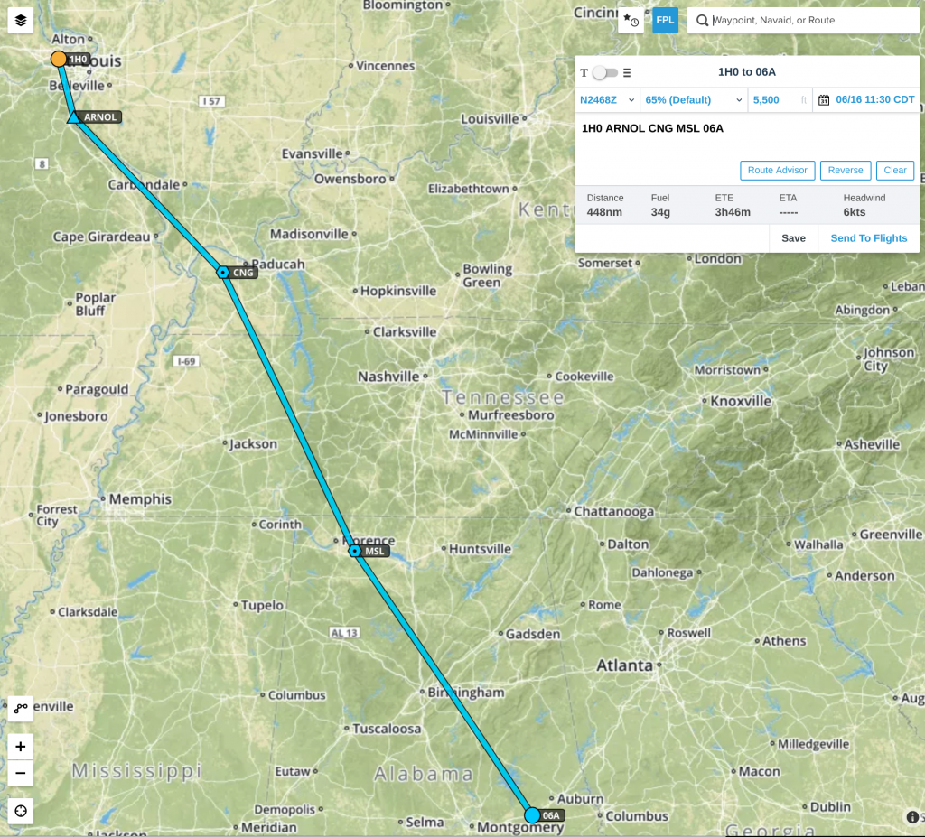
My plan was simple. Fly to Fort Pierce with a lunch stop in Moton, AL. With luck, I would even be able to sneak in a quick visit to the Tuskegee Airmen National Historic Site on the field. The first leg would be an easy flight over pretty countryside.
My second leg was slightly more complex, since the southeast corner of the country has bunches of military restricted airspace and Florida has airspace which belongs to Orlando and Tampa, all of which I needed to avoid. Even so, the plan was pretty straightforward, with just a couple of turns to scoot around the south edge of Orlando’s airspace.
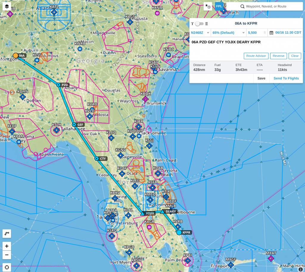
It didn’t work out that way. I ended up making three stops, not one; missing the Tuskegee Airmen; and arriving two hours later than intended. On the plus side, I got some of the best brisket I have ever had and I got to dance with clouds.
Leg 1: Creve Coeur to Moton Sikeston
My departure from Creve Coeur was completely normal. I flew south past West County Shopping Center and headed southeast, climbing to my cruising altitude of 5500 feet. I opened my VFR flight plan (a “just in case” plan should it be necessary to come searching for me). Then I contacted St. Louis departure for VFR flight following. It is always nice to have additional eyes on radar screens looking out for traffic which might bump into me.
About an hour into the flight, I was given a frequency change to talk to a different air traffic controller. When I switched my radio to the new frequency, it stopped working. The display was still lit but I could neither receive nor transmit. None of the knobs would do anything. Worse, the power button would not do anything, either. Back in the good old days, power buttons were physical switches; no longer.
I plan to install a second radio in the airplane later this year but, as of now, I only have one. Legally, I could have continued my flight but it would have been much dicier without a communication radio. I decided to land at Sikeston. I switched my transponder to the special “lost communications” code, telling air traffic control that I was not in any danger but would no longer be following the flight plan that we had previously agreed to. I turned southwest and landed at Sikeston.
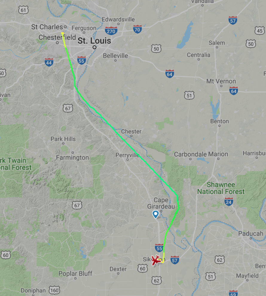
Once on the ground, I turned off the master electrical switch, turned it back on, and the radio operated normally. Of course.
I called Candy to let her know what was going on. Then I filled up the fuel tanks, filed an updated flight plan, and took off on my second attempt to fly to Moton, AL.
Leg 2: Sikeston to Moton Fayette
The flight started normally. I could see that Moton had low clouds and rain showers but both were due to move out to the east before I got there. I opened up Spotify, fired up a playlist of road trip songs, and sat back to enjoy the scenery.
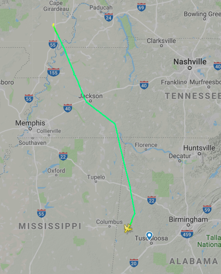
Old Man Weather nixed my plans for lunch in Moton. The clouds did not move out. I consulted Foreflight on my iPad and selected Richard Arthur Field (M95) in Fayette, AL as an alternate. It has relatively inexpensive fuel and several restaurants just a few miles from the airport.
After I landed, Richard Arthur Field turned out to be less inviting that I had hoped. The self-service fuel station looked newish but I could not see either a ladder or a step stool. I need something to reach the fuel tanks on the tops of my wings. Nor could I see any people around to ask for help. Nor could I see any way to get a ride into town and lunch.
Leg 3: Fayette to Demopolis
I did not even shut off the engine. I consulted Foreflight again and picked Demopolis Regional Airport (KDYA) for lunch. It was just 75 nm south and I landed 40 minutes later to the smell of fresh cut lumber, with the airport next to a huge lumber mill.
Very friendly people greeted me on the ground at KDYA, helped me park and fuel the plane, and directed me to Canecutters Smokehouse & Grill for some of the best brisket I have ever had. It took all of my available willpower to leave without also sampling their peach cobbler but brisket, bakes beans, green beans, and cornbread had me stuffed to the gills. And did I mention their spicy BBQ sauce? OMG!
After lunch, I checked on the weather for the remainder of the trip and was discouraged to see that the line of storms across the northern part of Florida were persisting, instead of moving away to the east as the weather forecasts has promised. I was going to need to divert due south in hopes of getting around the western end of the line of storms but that looked dubious. I reset my expectations, thinking that I would be spending the night in southern Georgia and arriving in Florida the next day.
Leg 4: Demopolis to Fort Pierce
Ultimately, the weather delayed me but did not prevent me from getting to Fort Pierce. I flew around one set of rain clouds, under a second, and then had a decision to make. There was all sorts of ugly bright colors on the radar between my position northwest of Tallahassee and Fort Pierce. As I approached Tallahassee, couple of cells of intense rain started forming to my west. I had three options:
- Land in the Tallahassee area and wait for morning.
- Turn around and fly northwest away from the weather.
- Fly due south, past the coastline, and see if the thunderstorms really did stop at the coast, as the radar indicated.
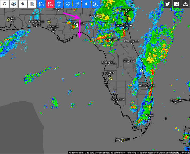
Air traffic control’s radar depicts weather poorly, so the controller had no info for me. I had the ADS-B radar images on my iPad, which are derived from the NWS weather radar, but I did not know how far into the Gulf of Mexico the NWS covered. Looking out the windshield, I could see a line of cumulus with a definite end due south of me, and it was moving eastward.
I decided to fly south, past the western end of the line of cumulus clouds. If I got past the line and found more clouds, I would return to Tallahassee and land for the night. Here is the radar from approximately the time that I flew past Tallahassee, with my route of flight in magenta.
I turned south and climbed up to 9,500 feet. Altitude is good, especially when flying over water. If I had had engine trouble, more altitude would have given me more time and distance to get back to dry land.
The flight went exactly as I hoped. When I got past the line of clouds, there was nothing but clear air behind it. I turned southeast and headed for Fort Pierce. For all my fretting, I never even hit bumpy air.
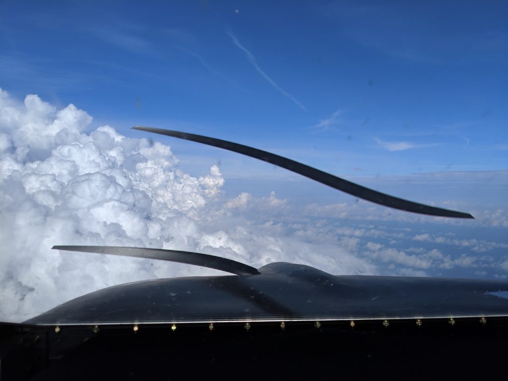
The rest of the flight was uneventful and I landed at Fort Pierce at about 7:45pm, almost 11 hours after departing Creve Coeur.
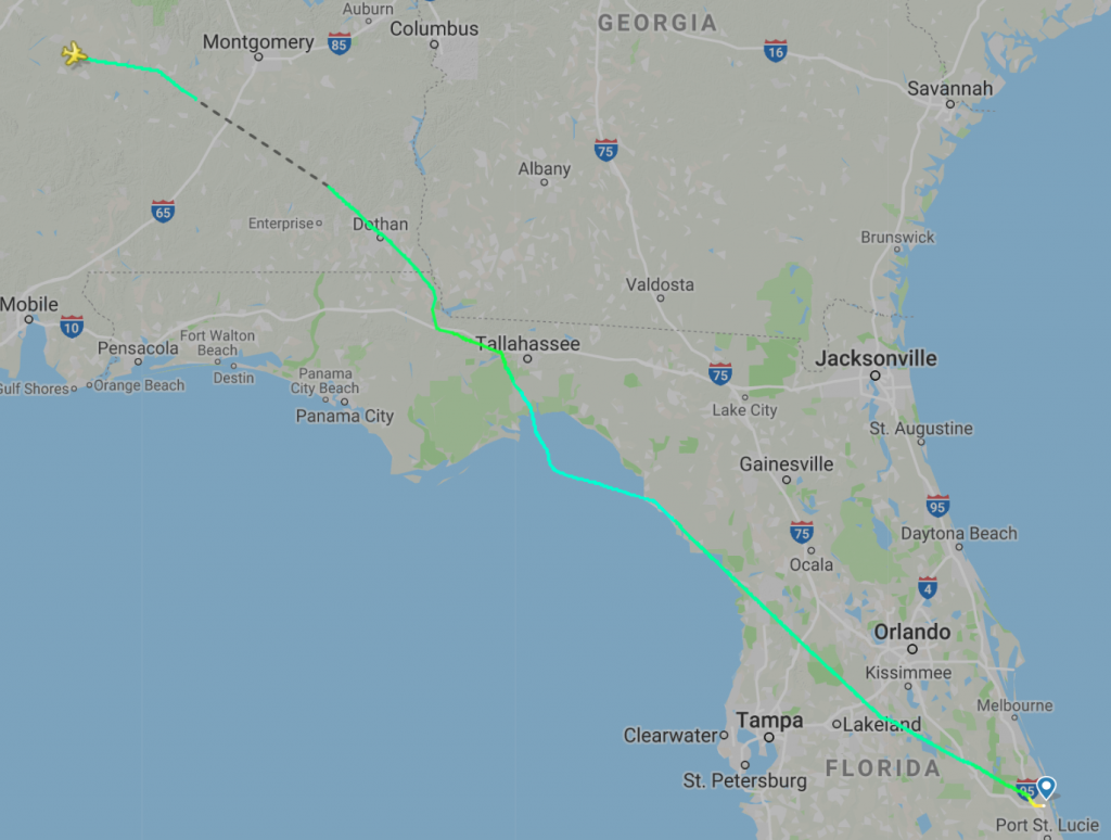
I spent 8.5 hours in the air and landed grinning from ear to ear.
Performance
I analyzed the performance on two sections of the last leg, one at 5,500 feet and the other at 9,500 feet. Note that these numbers are in a Bede BD-4C without fairings on the landing gear and without even taping up the gaps between the wings and the fuselage or the wings and the wingtips. (To get miles per hour, multiply knots by 1.15.)
5,500 Feet Altitude, 130 HP (65% power)
| Indicated Airspeed | 122 knots |
| True Airspeed | 138 knots |
| Fuel Flow | 9.5 gallons/hour |
9,500 Feet Altitude, 130 HP (65% power)
| Indicated Airspeed | 117 knots |
| True Airspeed | 141 knots |
| Fuel Flow | 9.1 gallons/hour |

Hi Art, maybe you can stop at Cannon Creek, 15FL. Would be great to see you and your plane, give me a call at 386-NNN-NNNN if I don’t answer just leave a message and I will call you back
Regards
Earl
So with your 8.5 hours of flight time, what was your speed?
Excellent question, Rob. I added a performance section to the blog post with indicated airspeed, true airspeed, and fuel flow. I calculated the values at both 5,500 and 9,500 feet.
What a great adventurous 1st cross country. I love the clouds video. Thanks for posting that. In redoing my panel I set up one of my COM antenna cables so I could unhook it form the planes radio and hook it into my Sporty’s handheld NAV COM.
You are an inspiration sir!! So cool to see you enjoying your build, thanks (again) for sharing the build journey.
Would like to hear any follow-up you do on the radio issue, either here or one of the forums. Hearing real world problems, and real world customer service accounts, is vital for those of us still making equipment decisions.
What takes you to Bede Mecca (if I might pry)?
Thanks, John.
I talked to the radio manufacturer and I think the problem is in how I built the radio subpanel. I think that the radio bezel is “bottoming out” against the front of the instrument panel, preventing the radio from seating fulling in the connector on the back. This could cause occasional, very brief power interruptions. It could also explain a second problem that I have been having the the RS232 connection to the navigation radio.
I am in Florida for repairs to the fuel tank in the right wing. But that is a story for a whole blog post of its own. Stay tuned. 🙂
Art,
Where did you get that beautiful carbon fibre engine cowling from?
I bought it from Bede Aero. Call Tim and he ought to be able to set you up with one.
Art,
I’m envious. While you flew your BD-4C from Missouri, I drove for 12 hours from my former home in Sikeston, MO to my current home adjacent to Wakulla County airport 2J0 south of Tallahassee FL. Your flight track crossed near our airport.
All while my BD-4C sits in my hangar awaiting transport to Fort Pierce for installation of avionics and instrumentation. I hope to fly my plane this year.
Best wishes to you
You’re right. I practically flew over 2J0 and didn’t even know that you were moving there. Worse, I didn’t know that you were building another BD-4C just a couple hours south of me at KSIK.